Modeling Tools
Global Earth System Model
The global Earth system model used for this project is the Community Earth System Model (CESM) (http://www.cesm.ucar.edu/) developed by the National Center for Atmospheric Research (NCAR). CESM is a leading US Earth System Model and has a long history of participating in the Intergovernmental Panel on Climate Change (IPCC) activities. Although majority of its climate simulations have been carried out at a nominal resolution of 1°, NCAR does maintain a high-resolution version of the coupled model for research purposes. The high-resolution version of CESM uses 0.25° horizontal resolution in its atmospheric and land components, while the ocean and sea-ice components share the same 0.1° horizontal resolution. It has been successfully integrated for over 100 years and its solutions show many improvements compared to those of the work-horse nominal 1° resolution CESM simulations. Small at al. (2014) summarize the major improvements of the high-resolution (HR) CESM compared to the standard version. These include more realistic annual-mean sea surface temperature (SST) in the equatorial Pacific and El Niño-Southern Oscillation (see Figure), as well as reduced warm SST biases in all eastern boundary upwelling regions, including the notorious Benguela SST bias. Additionally, the HR-CESM simulation enables small-scale features of the climate system to be represented, such as ocean mesoscale eddies, air-sea interactions over ocean frontal zones, mesoscale systems generated by the Rockies, and tropical cyclones. We believe this HR-CESM can provide a viable framework for high-resolution global Earth System predictions.
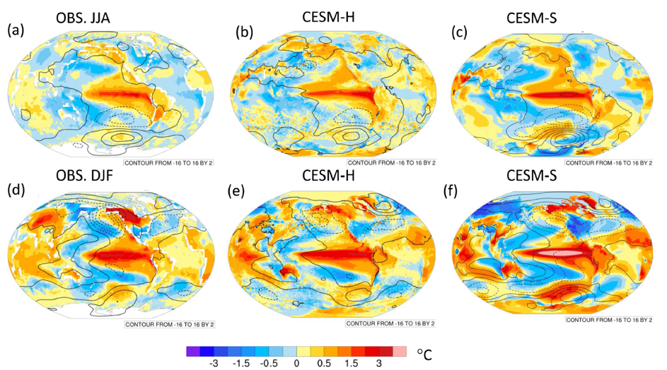
ENSO composites based on warm minus cold events of greater than standard deviation of Nino3.4 time series. (a–c) For June-July-August (JJA) before the peak and (d–f) for following December-January-February (DJF). Years 1920–2011 of HadISST and NOAA Merged Land-Ocean Surface Temperature Analysis (MLOST) [Smith and Reynolds, 2005] land surface temperature, and sea level pressure (SLP) from the twentieth Century Reanalysis [Compo et al., 2011] (a & d). High-resolution CESM years 15–100 (Figures b & e), and low-resolution CESM, years 1–166 (Figures c & f). Surface temperature (°C, color) and SLP (contours—interval 2hPa). (After Small et al., 2014)
Progress and Current Status
A concerted effort has made to port and optimize the HR-CESM code to the heterogeneous HPC system of TaihuLight in Wuxi, China (https://www.top500.org/system/178764). The current version of the high-resolution CESM1.3 code has achieved a throughput rate of 3 model simulation years per day (MSYD) using approximately 25% of computing nodes of the TiahuLight HPC system. The effort is continuing to improve the performance of the HR-CESM on TaihuLight. The goal is to achieve a throughput rate of 5 MSYD within one year.
Regional Earth System Model
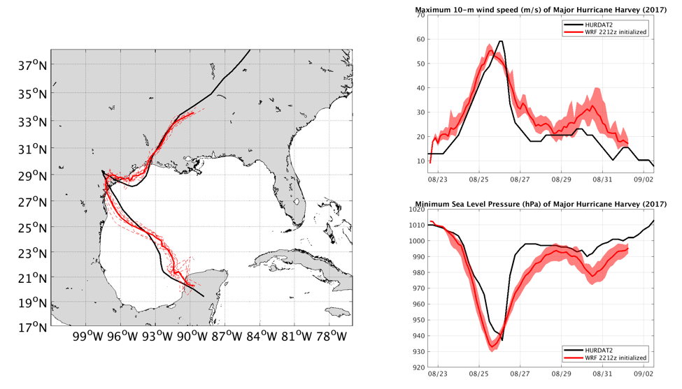
Hurricane Harvey simulated by a 3 km resolution R-CESM from August 22 to September 2, 2017.
Hurricane Harvey
Progress and Current Status
New capabilities have been added to R-CESM, including a) option to run R-CESM using CESM2 framework, i.e. using CESM2 air-sea and air-land fluxes, and optionally the CESM land model-CLM, and b) an option to embed ROMS in the global POP model.
Research & Projects
ResearchModeling ToolsProject 1: High-resolution CESM present and future climate simulationsProject 2: High-resolution ensemble CESM decadal climate predictionProject 3: High-resolution ocean model improvement and development Project 4: Development of R-CESM and online nesting capability for CESMProject 5: Development of online coupled data assimilation capability for R-CESM and CESM
